 |
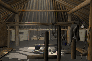
3D model of earthlodge interior:
Justin Hawley and Douglas Snider
|
The Like-A-Fishhook Story
Prior to the coming of European Americans, the Mandan, Hidatsa,
and Arikara tribes of the Middle Missouri River resided in
sedentary earth-lodge communities. Despite a basic similarity
of economic and social life, these peoples differed remarkably
in language and customs; the Mandan and Hidatsa speak a Siouan
dialect, while the Arikara, related to the Pawnee, are members
of the Caddoan linguistic group. One of the most important
historic sites of the Northern Plains was Like-a-Fishhook
Village, which was occupied simultaneously by all three tribes,
known today officially as the Three Affiliated Tribes.
Like-A-Fishhook Village, also known as Fort Berthold, was
located north of the confluence of the Missouri and Knife
rivers in central North Dakota. As the last earth-lodge settlement
of the Northern Plains, the site documents an extraordinary
episode of cultural transformation (Smith 1972). The village
was initially founded in the aftermath of a devastating smallpox
epidemic in 1837. The Mandan population was most heavily affected
by the epidemic, being reduced to fewer than 200 individuals.
Though not as severely struck by this terrible disease, the
Arikara and Hidatsa populations shrank as well. Ethnohistorical
evidence suggests that the first permanent residents of Like-a-Fishhook
Village were Hidatsa who arrived in 1845 (Smith 1972:4-5).
They were joined shortly thereafter by a smaller group of
Mandan. At about the same time as the Hidatsa built their
first earth lodges, a white trading company established a
post at the site, with log structures and a stockade, which
eventually became known as Fort Berthold (dubbed Fort Berthold
I by G. Hubert Smith). By 1862, a new trading post (Fort Berthold
II), by a different trading company, had replaced the first,
which had burnt to the ground. Also around 1862, the Arikara
arrived, establishing themselves in a new section of the village,
building on the site of the first fort.
Over the decades, more European Americans moved into the region
and the area surrounding Like-A-Fishhook/Fort Berthold Village
changed significantly. In the 1860s, Fort Berthold, by then
a mixed community of Native Americans, European Americans,
and mixed bloods, "was a base for Federal military units
campaigning in the Dakota Territory against fugitive remnants"
of Native American tribes in the region (Smith 1972:17). In
the late 1880s the village was abandoned, as native residents
were force to leave the site and take up occupation on new
areas of the then Fort Berthold Indian Reservation.
The data recovery projects (archaeological salvage excavations)
were carried out at the site in 1950-52 and 1954 by the State
Historical Society of North Dakota, under contracts with the
National Park Service (NPS) and by the River Basin Surveys
of the Smithsonian Institute. Rising waters from the Garrison
Dam and Reservoir project ultimately inundated the site, which
now rests about a mile offshore under the waters of Lake Sakakawea
(Garrison Reservoir).
|